Years of operation: 2021-2023
PIs: C. Sofianou (Ephorate of Antiquities of Lasithi), T. Theodoulou (Ephorate of Underwater Antiquities), C. Knappett (Toronto), A. Shapland (Oxford)
Chiona Beach Project
Previous work
On the coastal plain of Palaikastro, in Eastern Crete, large areas of an extensive Bronze Age settlement as well as a sanctuary of the historical period have been excavated by members of the British School at Athens. From 1902 to 1906 excavations were conducted under the direction of R.C. Bosanquet and R.M. Dawkins. Work in the area was resumed in 1962-1963 by M. Popham and L.H. Sackett, from 1986-1996 by L.H. Sackett and J.A. MacGillivray, and from 2013-2015 by C. Knappett, N. Momigliano and A. Livarda.
The 1902-1906 excavations
Bosanquet and Dawkins revealed portions of a large and prosperous Bronze Age town in an area known locally as Roussolakkos. The town seems to have reached its largest extent in the MM III-LM I Neopalatial period, with substantial houses and wide streets forming blocks. It provides one of the clearest examples of Minoan town planning.
Around the plain there are signs of occupation from the 4th millennium BCE (Final Neolithic), though nothing from this period has been excavated. Occupation begins at Roussolakkos in the EM IIA period (mid-third millennium BCE). Despite a large structure in EM IIB under the later Block Chi, the settlement was probably a small village until the end of the Protopalatial period (c. 1750 BC), when signs of urbanism appear, such as drains, ashlar masonry, and planned streets. This is somewhat later than similar developments at sites like Knossos in central Crete. While the town continued to expand for the next 150 years or so, a dramatic catastrophe struck: the Theran eruption. While significant ashfall hit the site, as yet there is limited evidence for a tsunami. The settlement continued to prosper, until many buildings were burnt around 1450 BCE, in the LM IB period. Even in its aftermath, there were several phases of reoccupation, although the site never took on the ‘Mycenaean’ characteristics seen elsewhere on the island.
The site is much more than just a town though. Around the settlement are various cemeteries, spanning much of the life of the town, albeit with a gap in the Neopalatial period. Above and to the south of the settlement is the Petsophas peak sanctuary, in use through the Proto- and Neopalatial periods, and the source of many terracotta figurines and several stone offering tables with Linear A inscriptions. And there is also a refuge site, located on the low hill of Kastri next to the sea, where some townsfolk appear to have lived for a generation or two once Roussolakkos was abandoned at the end of the LM IIIB period. Then once Kastri too had been abandoned, the area seems not to have been inhabited for a few centuries. Some time in the 8th century BCE a sanctuary to Diktaean Zeus was founded in the ruins of what was once Block Chi. An ash altar, bronze tripod-cauldrons, shields and other votives attest to cult activities taking place in the open air. A first temple may have been erected in the 6th century BCE. Cult continued into the Roman period.
The 1962-1963 and 1986-1996 and later campaigns
In 1962-1963 investigations were resumed by L.H. Sackett and M.R. Popham with excavations at both Roussolakkos and Kastri. Their work at Roussolakkos produced further evidence for the Minoan settlement, notably the well-preserved LM IB House N. Kastri produced remains of the EM III period (c. 2000 BCE) as well as LM IIIC.
Rescue excavations by the Greek Archaeological service in 1971-1978 revealed a kiln, two houses to the east of the town and more material from Petsophas. In 1986 excavations on a larger scale began to the north of the old excavations at Roussolakkos by L.H. Sackett and J.A. MacGillivray. Seven further buildings were uncovered (Buildings 1 to 7). These investigations provided important new information on the different destructions and phases of reoccupation of the site. From an LM IB (c. 1450 BCE) destruction level comes a wealth of finely crafted objects, including the Palaikastro Kouros, the gold and ivory statuette of a young male with steatite head and rock crystal eyes.
Palace and Landscape at Palaikastro 2013-2015
Excavation further east than had previously been undertaken began in 2013 with the aim of exploring early urbanism in Bronze Age Crete and the development of the cultural and natural landscape in the area. Three buildings were located, dating to different points in the Middle and Late Bronze Age. Building AP1 may have first been built in the Middle Minoan period, and was decorated with frescoes in blue paint with flecked designs. It had a small building next to it, MP1, which may have served as a kind of auxiliary building. Both seem to have been rendered uninhabitable by the ashfall and subsequent flooding associated with the Theran eruption. They were replaced by a new building constructed next door, AM1, which only lasted a few decades before it was abandoned in the LM IB period. Eventually both AM1 and AP1 were reused in the 14th century BCE (Postpalatial period), with signs of industrial production of purple dye in the former. Soon both structures were again abandoned, for the area never to be reoccupied.
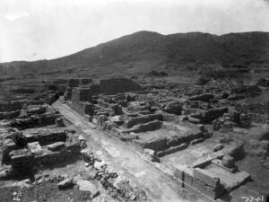
Palekastro during excavation in 1902-1904 (BSA Archive)
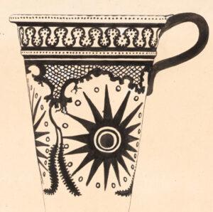
Drawing of a conical rhyton from Palaikastro, used in the BSA’s 50th anniversary exhibition in 1936 (BSA Archive)
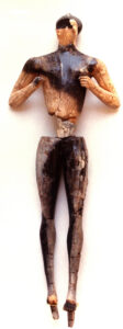
The Palaikastro kouros
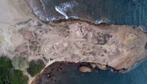
The Chiona Beach Project: Bronze Age
The most recent project has mapped Minoan structures underwater in Kouremenos Bay and has excavated Minoan levels in four trenches on the shoreline.
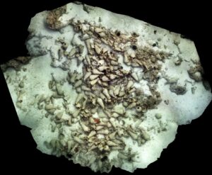
Underwater, in the northern half of Kouremenos, we located a submerged building at a depth of 2.5 m. There are at least two rooms discernible and a possible stone floor. Two further sections of walls with comparable structure and at similar depth were found a little further north. At this depth and with this kind of wall construction these structures are very likely to be Minoan. Further south in Kouremenos bay, just next to the hill of Kastri, a section of a circular structure was located, also at a depth of 2.5 m. Superficial cleaning inside the structure yielded sherds likely dating to the early 3rd millennium BCE. There are tholos structures of comparable size and construction that date to EM I elsewhere in east Crete (e.g. Mesorrachi, near Sitia). Immediately north of the building a series of large pithos fragments were located, concreted into sections of beach rock; these too are found at an average depth of 2-2.5m. One of them with rope decoration is of a distinctive type that can be dated to the Late Minoan I period.
A team from FORTH led by Dr. Nikos Papadopoulos conducted geophysical survey in 2023 in both Chiona and Kouremenos bays. Resistivity and radar were used on the coast itself, with underwater resistivity also done up to a depth of c. 1.5 m. Anomalies potentially due to walls were found on Kouremenos beach. Clear signs of structures were also found at East Beach.
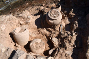
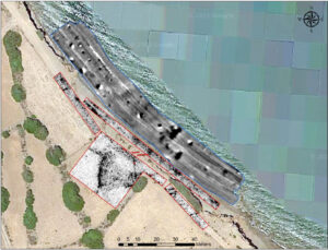
LM III storeroom excavated in zone 2
On shore, we excavated in four areas in 2022. On Chiona promontory, visible wall remains guided the placement of trenches. One such wall in zone 1 proved to be Hellenistic, with Minoan contexts of LM III A-B and LM IB date not far below. Zone 2 to the north revealed a substantial storeroom full of jars, dating to the LM III period. Levels dating to the Proto- and Neopalatial periods were also found, the former with traces of Theran ash. Evidently this coastal part of town saw continued occupation, much like neighbourhoods further inland. Zones 3 and 4 were located to the south of the promontory, on the East Beach, and in each case revealed finds of LM III, Neopalatial and Protopalatial periods.
Remains of Minoan building in north Kouremenos bay
Geophysics on East Beach, Chiona
Excavation zones 1 (left) and 2 (right), Chiona promontory
The Chiona Beach Project: Roman
Underwater, structures from the Roman period were located in both Kouremenos and Chiona bays. At Kouremenos we mapped a Roman mole (whose existence was already known) at a depth of 1-4 m, just to the northeast of the modern harbour. On the other side of this harbour was a series of submerged buildings at c. 1 m depth. Similar submerged buildings were also located at the north end of Chiona bay.
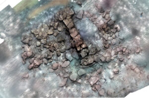
A significant discovery was made off Cape Plako: two Roman shipwrecks. The first, well-preserved and dating to the 2nd century CE, has ca. 240 amphorae currently visible, mostly of the Beltran IIB type, likely from southern Spain. It is about 13m long by 8m wide, and lies at a depth of between 19.5 and 23.5 m. Most of it is located on a sandy terrace, giving reason to believe that some of the wooden hull could be preserved beneath. The second, in shallower water, has four concentrations of amphorae. In addition to the west of Cape Plako five metal anchors were found, two probably Roman and three Byzantine, suggesting the common usage of the area as an anchorage.
Roman shipwreck with amphorae