Years of operation: 2021, 2023-2024 (field); 2022, 2024-2025 (study)
PIs: Olga Vassi (Ephorate of Antiquities of Chios), Andrew Bevan (UCL)
Previous work | Methodology | Emerging results | Back to BSA research
Years of operation: 2021, 2023-2024 (field); 2022, 2024-2025 (study)
PIs: Olga Vassi (Ephorate of Antiquities of Chios), Andrew Bevan (UCL)
Previous work | Methodology | Emerging results | Back to BSA research
Since 1934 the history and archaeology of Chios have provided a major focus of research interest for the BSA, with fieldwork taking place at sites such as Ayio Gala, Chios town, Dhelfinio, Emborio, Kato Fana and Pindakas.
Emborio loosely refers to a cluster of localities on the southeast coast of the island of Chios, including a double harbour with a small peninsular acropolis. Early detailed evidence for the character of the archaeology in this area was provided via excavation and informal survey by the British School from 1953 to 1955, directed by Sinclair Hood. This delineated successive levels at the acropolis dating to the Neolithic and Bronze Age (with particularly important stratified sequences spanning FN-EBA), as well as Mycenaean levels. Later, the harbour area at Emborio also hosted an Archaic sanctuary, a Late Roman fortified settlement on the acropolis and a nearby Early Christian church. On Profitis Ilias to the north, further British School excavations uncovered a temple dedicated to Athena on the top of the hill and, below that, various houses of a lower town spanning the period from the later 8th to end of the 7th centuries BCE.
Beyond the immediate vicinity of Emborio, in what still might be considered its agricultural and social hinterland, there are the remains of a well-known Medieval tower at Dotia. Informal survey in the 1950s also found a few other likely prehistoric surface scatters across the island, including ones near the modern villages of Pirgi and Kalamoti close to Emborio. A Classical period farm at Pindakas was also excavated by Boardman. More recently, there have been rescue excavations of Mycenaean through Archaic material in the harbour area by the Greek Archaeological Service, as well as further rescue work at Phoki south of Emborio. The latter revealed a small, cliff-top Final Neolithic-Early Bronze Age I site with evidence for several large coarseware storage vessels and other finds. To the west of Emborio, on the south coast, a British School survey and excavation project at Kato Phana uncovered one or two small prehistoric scatters but focused its efforts on documenting and excavating the important Mycenaean, Geometric and Archaic remains at a well-built sanctuary site (subsequently a Late Roman church). More recently, there has been a growing amount of research across the strait in the Çeşme-Izmir area and surrounds, especially addressing the Neolithic such as at Ege Gübre, Çukuriçi Höyük, Ulucak Höyük and Yeşilova Höyük or Bronze Age such as at Çeşme-Bağlararası and Limantepe.
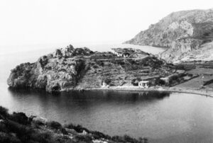
Emborio in the 1950s
The project has subjected some 10 sq km around Emborio to full-scale, multi-dimensional archaeological investigation, enhancing our understanding of the hinterland of the site’s prehistoric and Archaic communities, and contextualising a range of other known nearby evidence (such as FN-EB1 Phoki, Classical Pindakas and Medieval Dotia). In Aegean and Mediterranean terms, this is a small to medium-sized survey, and such a choice is deliberate, with a view to efficient, successful publication. The survey is ‘intensive’ in character, with individual surveyors walking in teams of 4-5 at 10m spacing. Each surveyor navigates with handheld GPS and records counts of the finds they observe, as well as making permanent collections of ‘diagnostic’ finds every 10m along each line. Diagnostic finds include all worked lithics, metal and glass, and all surface pottery finds that are handles, rims, bases or decorated sherds (body sherds and tile are only counted, not collected). The project is interested in all periods of the area’s history from deeper prehistory to the present.
About 75 per cent of the 10 square kilometre survey area was surveyed in 2021 and 2023, and the rest was completed in 2024 (total coverage 9.4 sq km). More than 60,000 potsherds and more than 10,000 tile fragments have been counted, and about 7500 diagnostic sherds collected for further study.
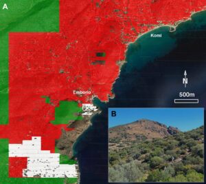
Map of the Emborio Hinterland Project survey area, with 2021, 2023 and 2024 coverage in white, red and green respectively. Inset, field team walking at 10m spacing.
Survey has generated prehistoric material concentrated around the Emborio headland, close to the location of the 1950s excavation trenches, including sherds of both Neolithic and Bronze Age date, and a limited number of lithics. A further cluster of prehistoric material was found around the known Early Bronze I (and possible FN) site of Phoki. The material is limited to the hilltop, but further prehistoric material of similar and possibly later date was found around another hilltop immediately to the southwest. In the wider survey area, very little additional prehistoric material has been noted. In all locations lithics of local chert are rare, and obsidian almost absent, although in 2024 one scatter of probably Neolithic chert was found in a relatively isolated small valley near the modern Chios Mastic Museum. Three additional scatters of prehistoric material were found in the vicinity of Emborio in 2024, and there is also some Middle and Late Bronze Age material at Metochi, with similarities both to Anatolian and to Mycenaean forms. The rather isolated prehistoric material contrasts with the seemingly denser use of the Çeşme peninsula just opposite.
Another striking initial result is the limited surface evidence surviving from around the 7th century BCE town on the hill of Profitis Ilias, perhaps due to erosion (a hypothesis with some geomorphological support).
Moving west down towards the Dotia valley, we documented a striking mix of discrete Archaic, Classical, Hellenistic, Roman, Late Roman and Medieval scatters. These may indicate agriculturally oriented farms or small estates, and there may be an Archaic cult site.
In the Emborio valley, a wider geoarchaeological pattern of hilltop erosion and valley bottom build-up obscuring possible prehistoric to Roman land surfaces is visible, but fortunately only within a relatively narrow tongue of land. By contrast, in the Komi valley to the northeast, the problem is more significant. We noted amphora fragments in section at depth in the modern riverbed, and a series of relatively dense pottery scatters on the eastern side of the valley giving way to a blank area in the main valley, devoid of almost any surface material apart from 19th-20th century CE ceramics. We hope to unpick these patterns of archaeological dearth, loss or concealment via further study.
More straightforward is the very considerable amount of evidence across all periods from ~650 BCE onwards, beginning in the Archaic, and through Classical, Hellenistic, Roman, Late Roman, Medieval, Ottoman and Recent. The Archaic period is, as we might expect from the rich evidence elsewhere on Chios, a peak period, with a lot of coarse and fine-decorated ceramics, tile and surviving wall foundations at several sites.
We conducted a high quality drone-based survey of major sites in 2023 and, including a new a rock art site on the northern slopes of Profitis Ilias in which the underside of a small rock shelter has been painted in red pigment with a design of multiple circles-with-stems, bordered by parallel lines. We also implemented a programme of terrestrial geophysics in 2024, but the results from several different tested areas were unconvincing.
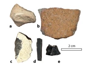
Late Neolithic and possible Early Bronze Age finds.
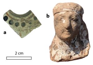
White-slipped, Archaic finds from 2023 fieldwalking, probably of 6th century BCE Chian manufacture: (a) fragment of a wine jug, (b) head of a painted female figurine.