Toumba Serron Project

Years of operation: 2021 (survey), 2022-2024 (excavation)
PIs: Dimitra Malamidou (Ephorate of Antiquities of Serres), James Taylor (York), Nicolas Zorzin (Université Paris 1 – Panthéon-Sorbonne)

Survey | Prospection | Excavation | GIS & TETRARCHS | Ongoing results | Back to BSA research

Survey

The project has undertaken survey using a comprehensive array of techniques to understand the site’s setting. Pedestrian survey was carried out over the northern, western, and southern sides of the Toumba. Within 50m x 5m rectangles all artefacts visible on the surface (sherds, lithic, shell, bone, remains of clay structures, etc.) were counted. In general, concentrations of pottery were particularly high on the top of the Toumba, remained high on the south slope, but were much less dense on its western and northern slopes. The slow diminution of surface material on the southern slope may indicate more intense activities in this area in the Late Neolithic period, or simply that material has been spread due to habitual north–south ploughing, following the slope. All diagnostic material found so far indicates a date for the site corresponding to the Late Neolithic period.

Survey on the Toumba was complemented by a general overview of its landscape, locating known Neolithic sites in the paleo-landscape. Inhabitants of Toumba village note that, during periods of flooding, the drained lake c. 500m south of the tell fills with water, suggesting this may have been an important resource for the Neolithic site.

Black on red sherds from the surface collection

Prospection

Prospection techniques used at the site and in its environs include drone survey, magnetometry, and coring. Drone survey was carried out over the southern and western slopes of the Toumba, covering an area of 17.27 ha.

Geophysical measurements were collected along parallel profiles 1m apart with a potassium magnetometer GSMP-25G in total field and vertical gradient modes. Another Overhauser magnetometer model GSM-19W was used to collect data for daily corrections for noise elimination, while a magnetic susceptibility meter KT- 10 was used to measure the difference in the magnetic properties of the soil, the bedrock, and large pieces of burned daub encountered on the surface. The resulting magnetometer map covers an area of 7.34 ha. Magnetic anomalies are recorded throughout most of the mapped area. Many of them correlate well with the results of similar surveys in Greece, Bulgaria and the Central Balkans, including those verified by excavation: anomalies characteristic of burned buildings, ovens and hearths on the hilltop, as well as on the adjacent slopes about midway to the foot of the mound. Some buildings appear radially arranged while others are arranged along parallel rows suggesting a possible diachronic difference which agrees with the ceramic data already recorded for the site.

Additionally 15 auger samples were obtained across the site. The aim of the drilling was to build upon the geophysical and pedestrian survey results, to begin modelling the deposits across the site. Preliminary analysis of the auger cores confirmed the presence of Late Neolithic activity on the site at a depth of between 1.60–2.00m below ground surface and indicated that there are probably two main phases of archaeological activity in the area sampled.

Magnetometer survey

Magnetometer survey of the Toumba

Excavation

excavation Trench locations

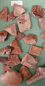
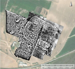
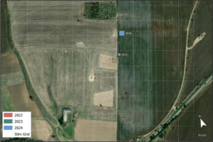
Conducted in 2022-24, the focus was on understanding the nature of the deposits, refining chronology, uncovering a representative Late Neolithic structure, and examining a large linear feature which from the magnetometry survey might form a wall, or a ditch and bank. Four trenches were opened in 2022 based on the magnetometry survey, with a further two in 2023 and two more in 2024. Trench G5.73 and G5.83 demonstrated two sub-phases within LN I, exposing an earlier building about 2.9m wide, with mudbrick walls and postholes for the superstructure, perhaps destroyed by fire. Part of a later building (still LN I) was also exposed in this trench.

Further north, Trench I6.21, excavated in 2024, revealed a potential kiln (oval, 1.6m x 1.0m, with a clay floor 0.7m x 0.7m), an associated waste deposit and an oval house (4.3m x 2.95m) made using mud in the pisé technique. The house was of the LN II period, and may have had an open area to the east.

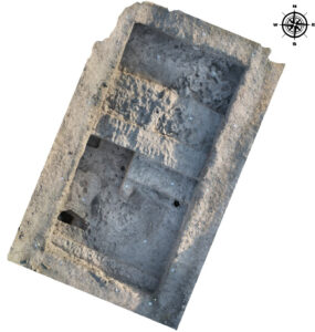
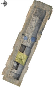
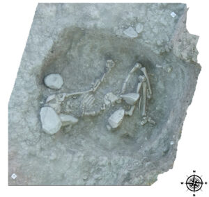
The linear feature was excavated in Trench H8.99, measuring 20m x 3m and set across the feature, which proved to be an earthen wall (mud or turf) about 3.5m wide. In a potential ditch associated with the wall two burials were excavated. As yet undated, these burials may prove significant as no Late Neolithic burials are known in the region. Further excavation nearby in 2024 in Trench I8.93 revealed more of the wall in association with LH I pottery. Excavation nearby uncovered a pit with LN I material (I8.92) and a potential dump area with mixed LN I and LN II pottery (I8.73).

The excavation has met its primary objectives and yielded significant findings. Notably, the unearthing of complete houses from both LN I and LN II periods, along with associated household structures such as a possible kiln and yard, provides new insights into the settlement’s structural phases. The LN II discovery is particularly remarkable, as in situ residential remains from this period had not been found in previous seasons, challenging the assumption that LN II residential strata on the hill had been largely destroyed. Furthermore, the continuation of the enclosure wall to the east was confirmed, validating the geophysical survey results. These findings suggest that the enclosure wall was actively used throughout the Late Neolithic I (LN I) period and possibly abandoned during the transition to LN II. The presence of a dump and previous discoveries of graves in previous seasons outside the enclosure in the northern region of the site support this theory.


Feature 2

Feature 2 (eastern burial) in Trench H8.99

G5-73 G5-83

Trench G5.73 and G5.83, with two LN I buildings.


H8-99

Orthophoto of H8.99, showing earthen feature

GIS and TETRARCHS

The single context recording of the excavation was digitised using the Archaeological Interactive Reports (AIR) platform. This is a cloud based digital archive, developed by Paola Derudas and hosted by Lund University. It allows for the integrated deposition of the entire digitised and ‘born digital’ archive — including images, written records, spatial data and 3D data. This allowed the project to begin to optimise its born digital primary data acquisition using both digital SLR cameras and Unmanned Aerial Vehicles (UAVs). The project aims to build a comprehensive and openly available 3D GIS of the site data. This digital agenda is supported by the TETRARCHs project, for which the Toumba Serron project is a key case study. TETRARCHs aims to revolutionise how archaeological data is collected and utilised, emphasising its reusability for storytelling that engages diverse audiences.

Context information in Archaeological Interactive Report


Ongoing results

The archaeological interventions at Toumba Serron continue to be extremely productive, confirming the presence of structures linked to two phases of LNI activity on the site, and another of LN II. We have confirmed the existence of a substantial enclosure wall encompassing the settlement, measuring approximately 2.7m in width, and extending over a length of around 900m. This enclosure wall is likely to belong to the Late Neolithic I period.

The presence of human remains on the site has the potential to significantly raise the profile and significance of the site, especially if they turn out to be Late Neolithic, since this is unprecedented in this part of Greece.

The preliminary examination of lithic material, encompassing blade and core assemblages, along with the study of zooarchaeological findings, has provided us with valuable insights and introduced fresh questions regarding the site’s history. Lithic macro analysis has confirmed that most of the artefacts are crafted from flint, sourced from the local mountains of Nigrita, located approximately 30km southwest of Toumba, as well as from the Rhodope mountain range to the north. Some of the blades display evidence of wear linked to the cutting of cereals and weeds. The current lithic collection aligns with the typical lithic tool production of the region; no obsidian artifacts have been identified thus far. In our preliminary zooarchaeological analysis, the most prevalent animal taxa consumed at Toumba were caprine, accounting for nearly 60% of remains. This aligns with expected patterns for a Late Neolithic site in Greece. However, what sets Toumba apart is that pigs rank as the second most common taxon (23%), followed by cattle (18%). Age at death analysis of caprines suggests that milk production was likely ongoing at Toumba. A particularly intriguing discovery is the relatively high presence of caprine and pig foetuses and neonates, which correlates with an unusually elevated consumption of dogs. The current working hypothesis, which needs further testing, is that environmental stress may have been occurring in Toumba during the LN1 period. One potential consequence of this stress could be a higher mortality rate among caprine and pig foetuses, possibly triggered by factors like disease outbreaks or nutritional deficiencies. The consumption of dogs might have served as a response to this situation, helping to counterbalance the effect of these stressors on the local food supply

The enclosure wall in trench I8.92